LATEST GFS FORECAST AGREES WITH JTWC
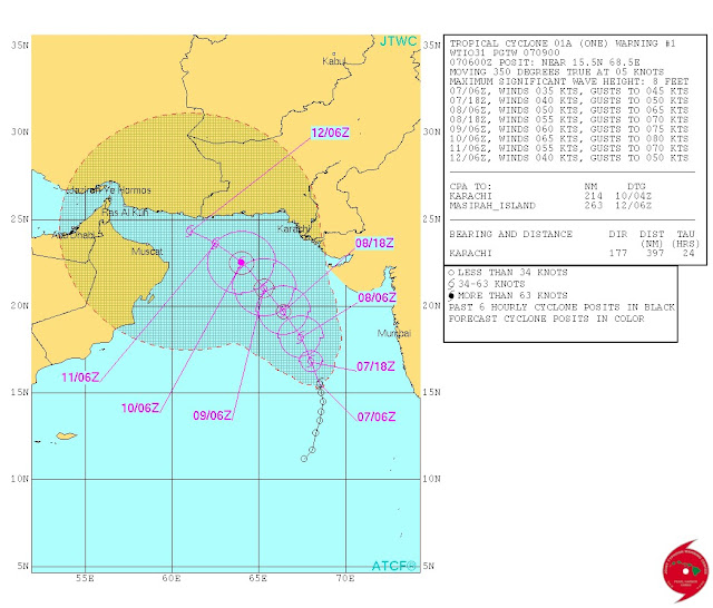
The latest GFS forecast (Issued at 0600 GMT today) agrees with the JTWC track for Arabian Sea tropical storm 1A.
The storm is seen in the Gulf of Oman on June 11, 2015.
There will be rains in northern Oman and even UAE on June 11-13, 2015.
 |
| XWF-WEATHER FORECAST MAP: CYCLONE ASHOBAA ON JUNE 11, 2015 |
The American Joint Typhoon Warning Center says the tropical cyclone has already formed in the Arabian Sea ths June 2015. It calls it 1A. According to it the system is already whipping up winds at 40 knots (75 kph).
According to its track forecast the cyclone is heading towards the Pakistan-Iran border.
++++++++++++++++++++++
June 7, 2015, 0630 GMT
ECMWF SAYS NO OMAN, CYCLONE ASHOBAA WILL WEAKEN AND ENTER SINDH JUNE 10, 2015.
Latest forecast data from the super accurate European model maintains that the upcoming tropical storm in the Arabian Sea this June 2015 will not go to Oman. It predicts that 95A will intensify into a storm by tomorrow morning and then move past the Saurashtra coast and weaken near the coast of Sindh on June 10, 2015. It will dissipate at landfall.
The European model and the American model are saying different things. Dissipate near Sindh or go to Oman? Who will be right?
Let us wait and see what the JTWC says in its 1100 hours GMT bulletin today.
++++++++++++++++++++++++++++++
Sunday June 7, 2015, 0530 GMT
Latest GFS track forecast for upcoming Arabian Sea cyclone.
Sunday June 7, 2015, 0500 GMT
Latest satellite image of 95A at 0000 hours GMT June 7, 2015. The exact track will become clear when JTWC comes up with its track forecast (At 1100 GMT today) within 24 hours. We also have to see what the European model says in its next forecast.
++++++++++
Sunday June 7, 2015, 0500 GMT
XWF-WEATHER FORECAST MAP: June 12-13, 2015
GFS predicts the Arabian Sea cyclone will bring heavy rains to northern Oman and UAE.
+++++++++++++
Latest forecast data from GFS....... 95A will turn into a tropical storm by tomorrow morning........ It will move north-north-west at first. By June 9 morning it will curve westward...... By the morning of June 10, it will be a few hundred kilometers from coast of northern Oman. It will be a cyclone with a central pressure of 989 mb by then...... Ashobaa will hit northern Oman (Muscat included) on June 11, 2015...... It will move along the coast. There might be rains in UAE too by June 13. The ECMWF data will come at 0630 GMT.
±++++++++++++++++
Latest image of 95A. It is getting organized now. Confusion persists amongst forecast models about the the track of upcoming tropical cyclone Ashobaa. The ECMWF says it will weaken and dissipate near Sindh coast. GFS, JMA, CMC and UKMET says it will go to Oman NAVGEM says it will make landfall on Pakistan-Iran border on June 11, 2015.


No comments:
Post a Comment