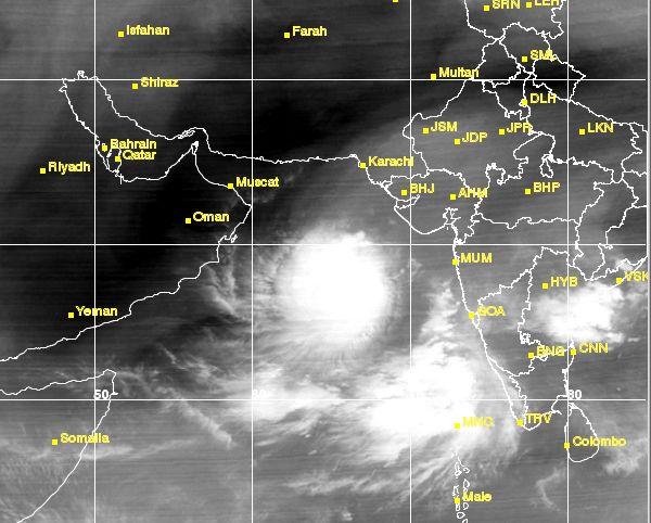
The question is where will it go?
There are disagreements amongst leading computer forecast models as to its future.
The JTWC and GFS (Global Forecast System) predict it will go to the Gulf of Oman. The JTWC does not say anything further. The GFS envisages the cyclone hitting the northern tip of Oman (Muscat included) on June 10, 2015, and then moving into the United Arab Emirates after that.
The JTWC says it is not very sure about the track forecast it has given out.
The other reliable model the ECMWF, the European Model, predicts tropical cyclone 1A will intensify today and then start weakening by tomorrow (June 9, 2015). It predicts its demise in the sea near the Kachchh-Sindh coast by June 10,2015.
The IMD says nothing about the future of the Arabian Sea tropical cyclone. It is just giving the current status, no forecasts.
UPDATE
LATEST ECMWF FORECAST: June 8, 2015. 0000 hours GMT
Something new and different. It says Arabian Sea tropical cyclone 1A will intensify further in the next 24 hours. It will start weakening as it moves north-west by June 10. After that in the next 48 hours it will abruptly move southwards. It will dissipate on June 13, 2015 off the north-eastern coast of Oman in the sea itself.
UPDATE
Tropical cyclone 1A named cyclone ASHOBAA by IMD
It says.......
The deep depression over eastcentral Arabian Sea has moved north-northwestwards during past 6 hours and intensified further into a cyclonic storm (ASHOBAA), and lay centred at 0830 hours IST of 08th June 2015 near latitude 17.90 N and longitude 67.20 E, about 590 km west- southwest of Mumbai, 470 km southwest of Veraval and 960 km east-southeast of Masirah Island (Oman). It would move initially north-northwestwards and intensify further into a severe cyclonic storm during next 36 hours.
http://www.rsmcnewdelhi.imd.gov.in/images/cyclone_pdfs/indian_1_1433769515.pdf
 |
| SATELLITE IMAGE OF THE ARABIAN SEA CYCLONE TAKEN AT 0315 GMT, JUNE 8, 2015 |
 |
| RAINFALL FORECAST MAP: IF THE CYCLONE DOES GO TO OMAN, THIS IS THE RAINFALL IT IS GOING TO DUMP TILL JUNE 13, 2015. |
No comments:
Post a Comment