Friday, April 21, 2017

Stormy Arabian Sea Expected, Good Monsoon Rains In June

The CFS model is now predicting above average rainfall in Gujarat, Rajasthan, western Madhya Pradesh and parts of Maharashtra in June 2017. The Arabian Sea is expected to very stormy with excess rainfall of upto 300-400 mm. That is 300-400 mm of rainfall above the June average.

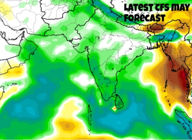
See the precipitation forecast map below. The blue denote heavier rainfall. The green and blue colors show above average rainfall. The orange and brown colors represent below normal, deficient rainfall.

We can thus see that monsoon is going to become very active in June. The heavy rainfall can be only because of low pressure systems/depression/tropical cyclone.

From the map we can also infer that Kerala, coastal Karnataka, Gujarat and parts of Rajasthan, Maharashtra, western Madhya Pradesh, and some northeastern states will see a wetter than normal June in 2017.

The south west monsoon will be very active during the entire month of June bringing good rains in many places. But it will turn weak in July.


Wednesday, May 4, 2016

Monitor North Indian Ocean (Arabian Sea, Bay of Bengal) Live


You can monitor North Indian Ocean (Bay of Bengal and Arabian Sea) and South Asia LIVE.

WIND SPEED MAP (LIVE) OF NORTH INDIAN OCEAN (ARABIAN SEA AND BAY OF BENGAL)


NORTH INDIAN OCEAN AND SOUTH ASIA RAINFALL MAP: WHERE IS IT RAINING NOW? WHITER THE PATCHES HEAVIER THE RAINFALL.

Monday, May 2, 2016

EXTREME WEATHER FORECAST MAY 2016

MONSOON WILL PUSH IN AROUND MAY 15
May 4, 2016

Below is the GFS forecast for May 15, 2016. It shows the high altitude 150 hPa winds. The easterly jet stream has been pushed up and the monsoon winds are arriving in the Andamans and Nicobar Islands.


TROPICAL CYCLONE UNLIKELY TILL MAY 22
May 4, 2016

The chances of a tropical cyclone developing in either the Arabian Sea or Bay of Bengal till May 22 seems remote. The CFS which had been hinting at a Arabian Sea storm by May end says today in its data that a cyclone is now likely in the Bay of Bengal in mid June. 

This has to be taken with a pinch of salt. Cyclones are inherently unpredictable. And May-June being storm seasons anything can happen anytime.


FORECAST TILL MAY 22
MAY 3, 2016

The next 20 days forecast indicates that
Subsequent to the likely rain spell over major parts of India during the first pentad,  heat wave conditions are likely to re-develop over parts of east & central India (viz., Gangetic west Bengal, Odisha, Vidarbha and Telangana) during 7th – 11th May.  This is likely to intensify and spread over to cover major parts of central and adjoining peninsular India and northwest India, during the period, 12th – 21st May.

Cyclogenesis is un-likely over the north Indian ocean during 2nd – 21st May.

However, cross equatorial flow in the lower troposphere is likely to reach south bay of Bengal and adjoining Andaman Sea around 15th May.

Likely eastward propagation of  the convective phase of MJO across the Indian ocean may cause a pre-monsoon rainfall peak, with above normal rainfall activity over extreme south peninsula during 12th – 21st May.

Western Disturbances are likely to cause above normal precipitation over western Himalayan region during 2nd – 6th May and 12th – 16th May.

CYCLONE ROANU IMMINENT AT MONTHS END?
May 2

Is a tropical cyclone brewing in the Arabian Sea?
Yes, if the Climate Forecast System, run by an US agency is to believed. 
The CFS though a climate forecast model gives daily updates. And it's data has been suggesting a cyclone forming near the Kerala coast around May 23, 2016 for the last few days.
The tropical cyclone ROANU will be a massive one and it will traverse northward in the Arabian Sea for a week.
At one time it seems it will hit Oman but it will swerve and hit Pakistan on June 1, 2016.
At present it is a mere possibility.
Support from weather models like the GFS and ECMWF is awaited.
Though the GFS in today's forecast data says a low pressure is likely to develop near the Indian Kerala coast on May 18.

Cyclone ROANU Arabian Sea

Sunday, May 1, 2016

MONSOON DYNAMICS

Upper air jet streams are high velocity winds which occur high up in Earth's atmosphere. Many kilometres up.

As the south west monsoon approaches the jet stream is pushed up over Tibet as temperatures there rise.

So the pushing up of the jet stream is one of the indicators that the monsoon is coming.

In fact the Jet Stream Theory says the shifting of the jet stream is the cause of the SW monsoon.


ABOVE AVERAGE RAINFALL LIKELY IN MAY 

Latest CFS monthly rain forecast for May 2016 is interesting.

The green and blue colors on India, Bangladesh, Pakistan, Sri Lanka and Oman indicates above average precipitation in these countries.

Pre-monsoon rainfall in May is likely to be vigorous this year. With 2 to 6 inches above average. In many areas.


-----------


CFS foresees 2 cyclones in North Indian Ocean by mid-June

The CFS model envisages two tropical cyclones developing by June 15, 2016. One in the Arabian Sea. Second in the Bay of Bengal.

The CFS being a climate model one cannot be sure of these predictions. One has to wait for confirmation from regular models like the GFS and ECMWF.


CFS model predicts Arabian Sea cyclone May end

The Climate Forecast Model, CFS, says a tropical cyclone may form by the end of May, 2016. There is presently an area of disturbed weather in southern Arabian Sea. This may drift eastward towards the Maldives and organise into a tropical cyclone (ROANU).


Friday, June 26, 2015

XWF INDICATIONS: Massive Typhoon Chan-Hom may Hit Hong Kong July 9, 2015

There is good likelihood that a massive typhoon may hit China at Hong Kong and Macau on July 9, 2015.

Presently it lies as Invest area 95W at 3.8 degrees north, 159.8 degrees east, south of Micronesia Islands. By June 30 it will gradually intensify into a tropical storm.

After that it will gradually turn into a typhoon and pass between Saipan and Guam islands on July 3, 2015. The US island of Songsong will suffer a direct hit.

Invest 95W, that is tropical cyclone Chan-hom will intensify further into something awful and pass just north of Luzon, Philippines, on July 7, 2015.

It will then swing southwards, kiss the southern Taiwan and go on to hit China at Hong Kong on June 9, 2015.

95W will be a deadly typhoon which will have an expected central pressure of 960 Mb when it passes Luzon.

Still more than ten days to go. So the track we have outlined is certainly going to change.

Alarm bells should ring in Guam, Philippines, Taiwan, Vietnam and China once Invest 95W turns into a tropical storm by June 30, 2015.

Monitor West Pacific Ocean LIVE

western pacific image typhoon chan-hom may hit hong kong July 9 2015
Satellite image of the Western Pacific Ocean. Invest 95W, the future typhoon Chan-hom has been born