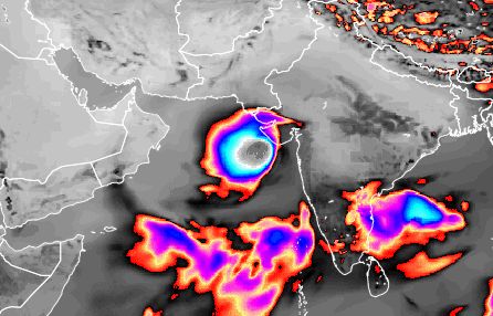
According to its latest model data issued at 0000 hours GMT, June 2, 2015, the cyclone will be born as a low pressure area off the coast of the Indian state of Karnataka on late June 5, 2015, that is Friday evening.
The forecast says the low pressure will start moving north and intensify into a cyclone within a day or two after that.
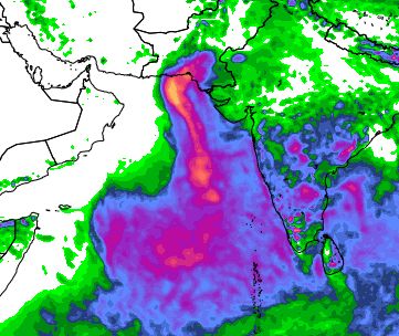
It is hard to predict its track/path and intensity accurately at this stage but what information we have says the storm will pass the Gujarat coast near Dwarka on June 9. After that it may enter Pakistan or it may weaken in the north Arabian Sea and its remnants will bring rainfall to northern Oman on June 13, 2015.
We have been hinting in the past few days at the good possibility of a cyclone developing in the Arabian Sea.
Other forecast models too predict the formation of a low pressure area in the Arabian Sea on June 5-6, 2015.
We can say more about forthcoming cyclone Ashobaa only after a couple of days, after the low pressure area materialises.
Interestingly, the not so reliable CMC model predicts the cyclone will hit southern Gujarat in the Gulf of Khambhat on June 9, 2015.
EXTRA UPDATE JUNE 2, 2015
The Arabian Sea low pressure area may develop as early in the next 48 hours, that is Thursday late evening. June 4, 2015
 |
| FORECAST MAP SHOWS THE CYCLONE ON JUNE 9, 2015 |
 |
| THIS IS WHERE THE RAINFALL WILL OCCUR (TILL JUNE 12, 2015) IF CYCLONE ASHOBAA HAPPENS AND FOLLOWS THE TRACK ACCORDING TO FORECASTS NOW |
No comments:
Post a Comment