Friday, June 26, 2015

XWF INDICATIONS: Massive Typhoon Chan-Hom may Hit Hong Kong July 9, 2015

There is good likelihood that a massive typhoon may hit China at Hong Kong and Macau on July 9, 2015.

Presently it lies as Invest area 95W at 3.8 degrees north, 159.8 degrees east, south of Micronesia Islands. By June 30 it will gradually intensify into a tropical storm.

After that it will gradually turn into a typhoon and pass between Saipan and Guam islands on July 3, 2015. The US island of Songsong will suffer a direct hit.

Invest 95W, that is tropical cyclone Chan-hom will intensify further into something awful and pass just north of Luzon, Philippines, on July 7, 2015.

It will then swing southwards, kiss the southern Taiwan and go on to hit China at Hong Kong on June 9, 2015.

95W will be a deadly typhoon which will have an expected central pressure of 960 Mb when it passes Luzon.

Still more than ten days to go. So the track we have outlined is certainly going to change.

Alarm bells should ring in Guam, Philippines, Taiwan, Vietnam and China once Invest 95W turns into a tropical storm by June 30, 2015.

Monitor West Pacific Ocean LIVE

western pacific image typhoon chan-hom may hit hong kong July 9 2015
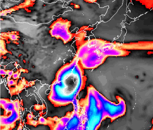
Satellite image of the Western Pacific Ocean. Invest 95W, the future typhoon Chan-hom has been born

Thursday, June 25, 2015

XWF INDICATIONS: Guam May Be Visited By Two Storms By July 5, 2015

Western Pacific Ocean is getting active again. It is likely that Guam may be affected by two storms by July 5, 2015.


The first one is likely to be a tropical depression which will come from the south and brush by Guam on June 30, 2015. It may not directly pass through the island but it may bring stormy weather as it sails by.

The second tropical storm is going to be a tougher customer.  With a central pressure of 991 Mb it going to be a windier storm system which will impact Guam directly on July 5, 2015.

XWF-INDICATIONS: Typhoons Looming In West Pacific By July 10, 2015.

Forecast models say at least two typhoons are likely to form in the West Pacific by early July, 2015.


The leading computer forecast models are a little confused.

One of them, the American GFS (Global Forecast), was predicting a powerful typhoon with a central pressure of 955 Mb hitting Hong Kong and Macau by July 8, 2015. But in the later forecast it predicts a different track. It expects a typhoon hitting Japan on July 8, 2015.

But there is a likelihood of a massive typhoon developing east  of  northern Philippines around July 4, 2015. This typhoon will skirt Luzon and go onto hit Taiwan on July 7, 2015. And after that it will move into mainland China in Fujian province on July 9.

The European model, the ECMWF, predicts a deep depression but it sees it swing north from Guam and drifting towards Taiwan around July 4, 2015. But it predicts another storm developing right behind it on July 4 in the Pacific near the Micronesian islands.

Keep in touch for more Xtreme weather indications and trends, forecasts.

western pacific ocean typhoon taiwan china july 2015
This is a GFS forecast map of July8, 2015

Wednesday, June 24, 2015

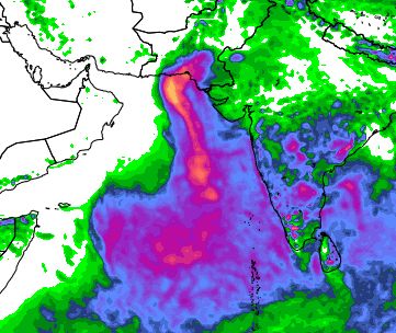
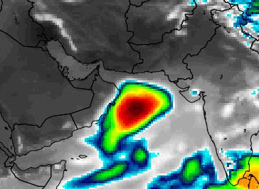
Arabian Sea Low Pressure: Heavy Rains In Saurashtra To Move To Central, South Gujarat

The depression in the Arabian Sea weakened and is moving through Amreli district. It will then cross over to central Gujarat and then Madhya Pradesh and Uttar Pradesh.

It is causing heavy rains in Saurashtra now. The rains in Saurashtra will move to central Gujarat by June 25, 2015. The rains in Saurashtra will cease by Thursday.

heavy rainfall gujarat saurashtra june 2015
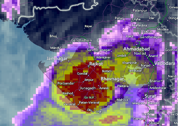
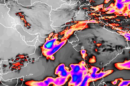
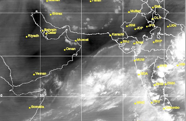
The satellite image shows heavy rainfall in Saurashtra presently on June 24, 2015

Friday, June 19, 2015

XWF-INDICATIONS: A depression to form soon in Arabian Sea

Latest GFS forecast says Arabian Sea low will turn into a depression by June 21, 2015.

Let us make one thing at the outset. We do not think a cyclone is possible at this stage of the monsoon. But a depression or deep depression is possible. We are just reporting what the GFS model has said just now.

But since we report any developments here are the details of the forecast....

The Arabian Sea is very turbulent presently. True. The GFS predicts that a group of circulations will coalesce by June 22,2015, into a cyclone or a deep depression, quite near the Oman coast.

It further says the system will potter around in the Arabian Sea for some days, weaken then drift into Kutch-Sindh border area on June 25, 2015.

The European model in it's latest update flatly denies any possibility of a tropical cyclone. It says the Arabian Sea low will stay close to the Saurashtra coast and then enter into Saurashtra on June 23, 2015.

The GFS in its latest forecast issued at 0600 GMT today says the Arabian Sea low will form tomorrow and intensify into a depression by Sunday.


cyclone komen arabian sea june 2015

Tuesday, June 9, 2015

Tropical Cyclone Ashobaa Coming To Northern Oman Thursday, June 11, 2015

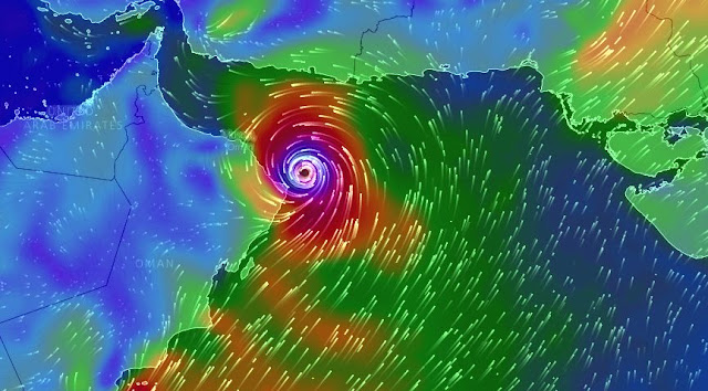
Major forecast models barring one predict that Arabian Sea tropical cyclone Ashobaa will make landfall into north-eastern coast of Oman on June 11, 2015.

The point of impact will be the town of Al Ashkharah.

The cyclone is currently moving in a NNW direction, but soon it will move in a north-westerly direction.

It is expected to intensify a little in the coming 24 hours. Wind speeds at the time of impact will be about 125 km/h.

After landfall the storm will move south west into Oman and dissipate completely.

Very heavy rainfall is expected in northeastern Oman in the next three days. Muscat will receive heavy showers on June 11-12, 2015.

Stormy weather will start to affect northeastern Oman from tomorrow itself as the storm comes near.

The Joint Typhoon Warning Center (JTWC), Fiji, predicts a direct hit on Muscat on June 12, but that seems doubtful.

We have made these forecasts on the basis of what the GFS forecast model issued by NOAA's NCEP (National Climate and Environmental Prediction center) says.

The European forecast model (ECMWF) differs drastically. It predicts the demise of cyclone Ashobaa mid sea in a couple of days.

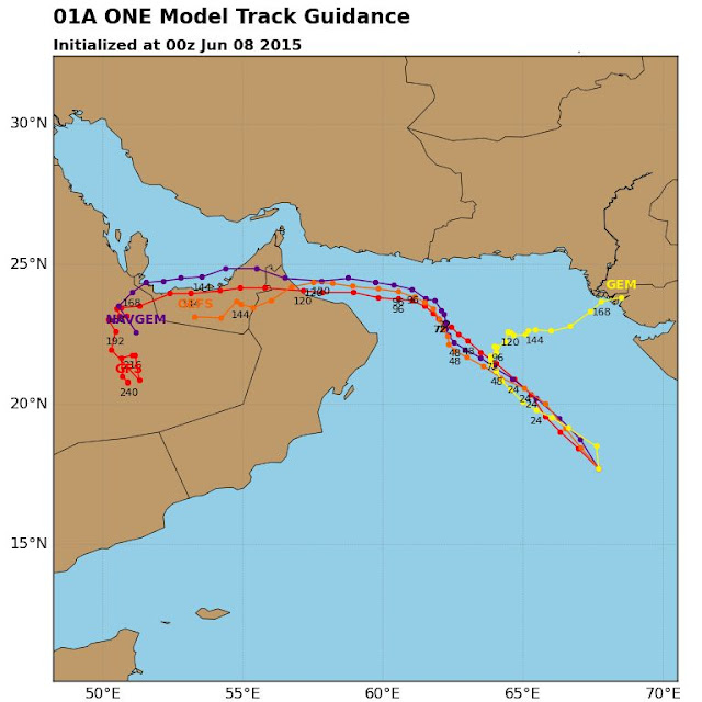
track forecast cyclone ashobaa 1a june 2015
TRACK FORECAST FOR CYCLONE ASHOBAA BY VARIOUS COMPUTER MODELS. THE RED LINE (GFS) IS THE MOST RELIABLE.

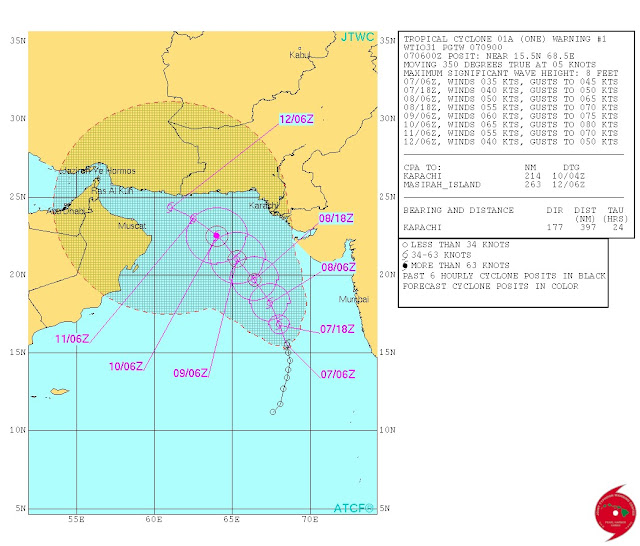
CYCLONE ASHOBAA JTWC TRACK FORECAST
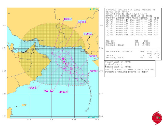
TRACK FORECAST FOR CYCLONE ASHOBAA BY JTWC

Monday, June 8, 2015

Arabian Sea Tropical Cyclone ASHOBAA Will Intensify Before Hitting North Oman June 12, 2015

Arabian Sea tropical cyclone Ashobaa will intensify even more before hitting the coast of northern Oman on June 12, 2015. It will weaken into a low after that and bringing heavy rains to United Arab Emirates on June 13, 2015.

The IMD (Indian Meteorological Department) has just christened the cyclone as Ashobaa and predicted that it will intensify further in the next 36 hours.

The entire coast of northern Oman will be affected from June 12, 2015. Strong winds and rainfall will start in Muscat from early morning.

The worst affected provinces will be Masqat, Al Batinah and northern Az Zahirah.

Though cyclone Ashobaa will have sustained winds of 140 kph, gusts up to 180 kph, on June 12, Muscat will get off relatively lightly as only the fringes of the storm will touch it.

The cyclone will make landfall in Al Batinah province. Hence most of the rains will fall there.

But there are still five days to go and this storm may change course. In that case Muscat will suffer a direct hit.

arabian sea tropical cyclone ashobaa track forecast june 2015 oman
THIS IS THE TRACK FORECAST FOR CYCLONE ASHOBAA. THE WIND SPEEDS ARE IN KNOTS.
track forecast cyclone ashobaa june 2015 oman
ALL FORECAST MODELS AGREE THAT TROPICAL CYCLONE ASHOBAA WILL MAKE LANDFALL INTO NORTHERN OMAN ON JUNE 12-13, 2015

Arabian Sea Tropical Cyclone 1A Is Officially Named ASHOBAA

ARABIAN SEA TROPICAL CYCLONE ASHOBAA WARNING

The Indian Meteorological Department (IMD) has named Arabian Sea cyclone 1A as 'ASHOBAA".

All forecast models agree that the cyclone will intensify further in the next 36 hours as it moves in a north westerly direction.

After that there is a good chance that the tropical cyclone might move onto northern Oman by June 10, 2015, but there is still some disagreement amongst computer models.

Keep in touch for our latest updates.

The IMD in its latest bulletin issued at 0530 hours GMT today said.....

The deep depression over eastcentral Arabian Sea has moved north-northwestwards during past 6 hours and intensified further into a cyclonic storm (ASHOBAA), and lay centred at 0830 hours IST of 08 th June 2015 near latitude 17.9 0 N and longitude 67.2 0 E, about 590 km westsouthwest of Mumbai, 470 km southwest of Veraval and 960 km east-southeast of Masirah Island (Oman). It would move initially north-northwestwards and intensify further into a severe cyclonic storm during next 36 hours.


Arabian Sea Tropical Cyclone 1A: Will It Go To Oman Or Break Up Mid Sea By June 10, 2015?

The Arabian Sea storm 1A is already a deep depression. The Joint Typhoon Warning Center calls it a tropical cyclone already. The IMD (Indian Meteorological Department) should christen it Ashobaa soon.

The question is where will it go?

There are disagreements amongst leading computer forecast models as to its future.

The JTWC and GFS (Global Forecast System) predict it will go to the Gulf of Oman. The JTWC does not say anything further. The GFS envisages the cyclone hitting the northern tip of Oman (Muscat included) on June 10, 2015, and then moving into the United Arab Emirates after that.

The JTWC says it is not very sure about the track forecast it has given out.

The other reliable model the ECMWF, the European Model, predicts tropical cyclone 1A will intensify today and then start weakening by tomorrow (June 9, 2015). It predicts its demise in the sea near the Kachchh-Sindh coast by June 10,2015.

The IMD says nothing about the future of the Arabian Sea tropical cyclone. It is just giving the current status, no forecasts.

UPDATE

LATEST ECMWF FORECAST: June 8, 2015. 0000 hours GMT

Something new and different. It says Arabian Sea tropical cyclone 1A will intensify further in the next 24 hours. It will start weakening as it moves north-west by June 10. After that in the next 48 hours it will abruptly move southwards. It will dissipate on June 13, 2015 off the north-eastern coast of Oman in the sea itself.

UPDATE

Tropical cyclone 1A named cyclone ASHOBAA by IMD

It says.......

The deep depression over eastcentral Arabian Sea has moved north-northwestwards during past 6 hours and intensified further into a cyclonic storm (ASHOBAA), and lay centred at 0830 hours IST of 08th June 2015 near latitude 17.90 N and longitude 67.20 E, about 590 km west- southwest of Mumbai, 470 km southwest of Veraval and 960 km east-southeast of Masirah Island (Oman). It would move initially north-northwestwards and intensify further into a severe cyclonic storm during next 36 hours.

http://www.rsmcnewdelhi.imd.gov.in/images/cyclone_pdfs/indian_1_1433769515.pdf


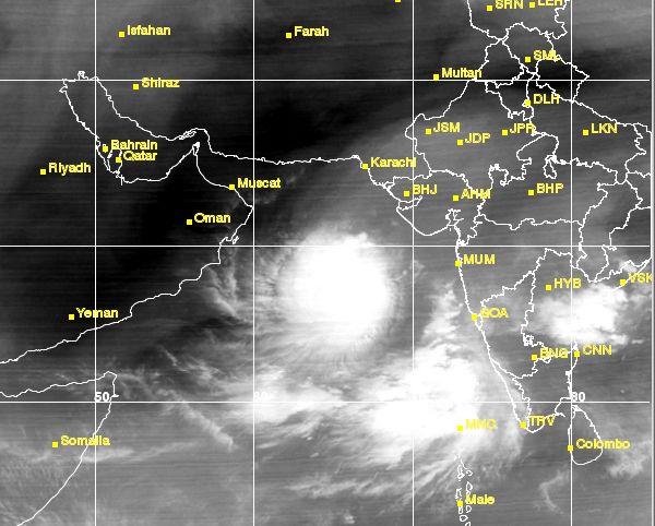
arabian sea tropical cyclone latest image oman
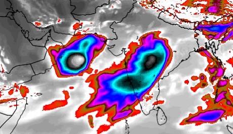
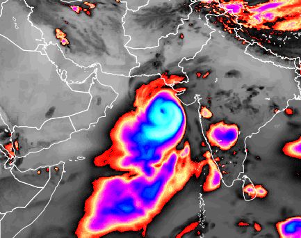
SATELLITE IMAGE OF THE ARABIAN SEA CYCLONE TAKEN AT 0315 GMT, JUNE 8, 2015
arabian sea tropical cyclone june 2015 rain forecast map
RAINFALL FORECAST MAP: IF THE CYCLONE DOES GO TO OMAN, THIS IS THE RAINFALL IT IS GOING TO DUMP TILL JUNE 13, 2015.

Sunday, June 7, 2015

Arabian Sea Tropical Cyclone Ashobaa: Latest Updates

It is now almost certain that the brewing Arabian Sea tropical storm which will be named Ashobaa is heading for northern Oman and then UAE.


By June 11, 2015 the cyclone will reach the Gulf of Oman. After that it will curve and then make landfall into Oman-UAE border areas on June 13, 2015.

So rains can be expected, along with stormy weather in parts of Northern Oman and then the United Arab Emirates on June 13, 2015.

latest satellite image arabian sea cyclone june 2015
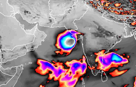
LATEST SATELLITE IMAGE OF ARABIAN SEA TROPICAL STORM AT 10.11 GMT, JUNE 7, 2015
June 7, 2015, 1030 GMT

LATEST GFS FORECAST AGREES WITH JTWC

The latest GFS forecast (Issued at 0600 GMT today) agrees with the JTWC track for Arabian Sea tropical storm 1A.

The storm is seen in the Gulf of Oman on June 11, 2015.

There will be rains in northern Oman and even UAE on June 11-13, 2015.


FORECAST MAP ARABIAN SEA CYCLONE OMAN 2015
XWF-WEATHER FORECAST MAP: CYCLONE ASHOBAA ON JUNE 11, 2015
JTWC SAYS 95A ALREADY A CYCLONE

The American Joint Typhoon Warning Center says the tropical cyclone has already formed in the Arabian Sea ths June 2015. It calls it 1A. According to it the system is already whipping up winds at 40 knots (75 kph).

According to its track forecast the cyclone is heading towards the Pakistan-Iran border.


TRACK FORECAST CYCLONE ASHOBAA JUNE 2015

++++++++++++++++++++++

June 7, 2015, 0630 GMT

ECMWF SAYS NO OMAN, CYCLONE ASHOBAA WILL WEAKEN AND ENTER SINDH JUNE 10, 2015. 

 Latest forecast data from the super accurate European model maintains that the upcoming tropical storm in the Arabian Sea this June 2015 will not go to Oman. It predicts that 95A will intensify into a storm by tomorrow morning and then move past the Saurashtra coast and weaken near the coast of Sindh on June 10, 2015. It will dissipate at landfall.

The European model and the American model are saying different things. Dissipate near Sindh or go to Oman? Who will be right?

Let us wait and see what the JTWC says in its 1100 hours GMT bulletin today.
++++++++++++++++++++++++++++++

Sunday June 7, 2015, 0530 GMT

Latest GFS track forecast for upcoming Arabian Sea cyclone.


Sunday June 7, 2015, 0500 GMT

Latest satellite image of 95A at 0000 hours GMT June 7, 2015. The exact track will become clear when JTWC comes up with its track forecast (At 1100 GMT today) within 24 hours. We also have to see what the European model says in its next forecast.

95A cyclone Ashobaa latest image June 2015

++++++++++

Sunday June 7, 2015, 0500 GMT


forecast map rainfall oman arabian sea cyclone ashobaa june 2015

XWF-WEATHER FORECAST MAP: June 12-13, 2015
 GFS predicts the Arabian Sea cyclone will bring heavy rains to northern Oman and UAE.
+++++++++++++
Latest forecast data from GFS....... 95A will turn into a tropical storm by tomorrow morning........ It will move north-north-west at first. By June 9 morning it will curve westward...... By the morning of June 10, it will be a few hundred kilometers from coast of northern Oman. It will be a cyclone with a central pressure of 989 mb by then...... Ashobaa will hit northern Oman (Muscat included) on June 11, 2015...... It will move along the coast. There might be rains in UAE too by June 13. The ECMWF data will come at 0630 GMT.
±++++++++++++++++

Latest image of 95A. It is getting organized now. Confusion persists amongst forecast models about the the track of upcoming tropical cyclone Ashobaa. The ECMWF says it will weaken and dissipate near Sindh coast. GFS, JMA, CMC and UKMET says it will go to Oman NAVGEM says it will make landfall on Pakistan-Iran border on June 11, 2015.

arabian sea tropical cyclone ashobaa june 2015 latest image

Saturday, June 6, 2015

Arabian Sea Invest 95A Will Remain A Rainmaker Low Or Depression

The present Invest 95A in the Arabian Sea is unlikely to intensify into a tropical cyclone. At most a low pressure area or a depression.

It is a low pressure trough presently. In the next 48 hours it will move north and organize into a low or a depression. It may dissipate near the coast of Saurashtra on June 8, 2015. Or it may go onto reach the coast of Oman on June 10.

It's present location is 12.5 degrees north, 67.4 degrees east.

By June 10, 2015 it will reach the north Oman coast where it will dissipate. Substantial rains are possible in Muscat and north-eastern coast of Oman on June 10, 2015. The rains will not reach Abu Dhabi.

In a year where the monsoons have begun weak, 95A has become a superstar. 95A may not become a big guy, but he may surely travel a lot in the coming days. Perhaps to Oman.

INVEST DEPRESSION 95A ARABIAN SEA JUNE 2015 OMAN HEAVY RAINFALL
XWF-WEATHER FORECAST MAP: JUNE 10, 2015. RAINS REACH OMAN

Friday, June 5, 2015

Invest 95A To Intensify And Move To Northern Oman June 10, 2015

The trough in central Arabian Sea, labeled Invest 95A by NOAA, will move north in the next 48 hours. On June 7 it will organise into a proper low pressure area and then into a deep depression or a tropical storm by June 8, 2015.

The system will move past Gujarat and head towards the Pakistan coast initially, but on June 9, 2015 (It will be a tropical storm then) it will curve and make landfall into Oman on June 10, 2015.

There is some disagreement between the various forecasts models. So we draw out an alternate scenario. According to another forecast the system will turn into a depression and dissipate near  the coast of Saurashtra on June 8, 2015, bringing heavy rains to coastal Saurashtra.

The exact future of Invest 95A is not certain now. It will be one of the two alternative scenarios we have drawn.

The picture will become clearer on June 7, 2015.

arabian sea storm june 2015 oman
XWF-WEATHER FORECAST MAP: JUNE 10, 2015. STORM 95A HITS OMAN


arabian sea tropical storm june 2015 oman invest 95A
SATELLITE IMAGE OF THE ARABIAN SEA TAKEN AT 1100 HOURS GMT TODAY

Thursday, June 4, 2015

Arabian Sea Tropical Cyclone To Form June 6, 2015. Target Northern Oman

It is called Invest 95A by NOAA. It is already a depression, with sustained winds of 50 kph. On late June 6, 2015, Saturday, it will intensify into tropical cyclone Ashobaa.

Presently it lies about 640 kilometers WSW of Lakshdweep. About 900 kilometers north east from Maldives.

In the next 48 hours it will move NNE at a steady clip then it will curve towards Oman.

Latest GFS forecasts say it will make landfall into northern Oman on June 10-11, 2015.

Very heavy rains are expected on the northern coast of Oman. Muscat included. The torrential rains will be accompanied with strong winds. Luckily for Oman the storm is expected to weaken by the time it reaches it.

Ashobaa is going to be a fast moving storm. It will take just four days from its christening on June 6 to reaching Oman on June 10, 2015.

Gujarat or the Pakistan coast will not receive any notable precipitation. Only the most northern coastal strip of Oman will get rainfall.  (On June June 10-11).

Ashobaa will not be a very powerful cyclone. At its peak it will have sustained winds of 120 kph.

Presently amongst the reliable forecast models, only the GFS is supporting the formation of a tropical cyclone in the Arabian Sea. The European model predicts that Invest 95A will not intensify into a cyclone but remain a low pressure area. Or a depression at best. The ECMWF says 95A will move north in the coming days and then dissipate near the Gujarat coast on June 8, 2015.

arabian sea storm low 95a cyclone ashobaa
SATELLITE IMAGE (0300 HRS GMT JUNE 4, 2015) OF INVEST 95A THE DEPRESSION IN THE ARABIAN SEA

Wednesday, June 3, 2015

INDICATIONS: Arabian Sea Cyclone ASHOBAA (Or A Depression?) Will Form June 6, 2015

It is almost certain that a powerful cyclone is going to form in the Arabian Sea within 72 hours, that is by June 6, 2015.

The tropical cyclone, which will be named ASHOBAA, will start off as an innocuous low pressure area in south east Arabian Sea tomorrow morning (Thursday, June 4, 2015).

This "low" will then move north into east central Arabian Sea and then intensify into cyclone Ashobaa, a few hundred kilometers west of the coast of Karnataka on June 6.

It will start moving north, intensifying all the time. By June 8, it will be whipping sustained winds of 150 kph. Quite a powerful storm.

It is then expected to start curving north-westerly; It will pass the Gujarat coast at Dwarka a few hundred kilometers away on June 8, 2015. It will then weaken slightly.

It will then go close to the Pakistan coast at Sindh-Balochistan border and then move along the coast until it reaches the Pakistan-Iran border area on June 10. It will then start weakening and dissipate in the Gulf Of Oman.

It is too early to be sure as to where the storm will ultimately go. Things will get clearer after the cyclone forms on June 6. Till then the sword hangs on Gujarat in India, Pakistani coastal provinces and Oman. Especially Oman.

Cyclone Ashobaa will not bring any significant rainfall to India but parts of southern Sindh and Balochistan will receive significant precipitation.

Oman is not expected to receive any rainfall.

We cannot be sure of the track of the impending cyclone at this stage. The exact track will become clear by June 6, when the low pressure will turn into a tropical cyclone.

We have based these predictions on the basis of forecast data we received from the GFS Model. The other reliable model the ECMWF predicts too that the "low" will form on June 4. But it predicts in its latest forecast that the system will remain only a depression and not intensify into a tropical cyclone. It also says the depression will dissipate near the coast of Gujarat on June 9, 2015.

The GFS Ensemble Model largely agrees with the European model. It predicts the demise of the system near the Pakistan coast on June 9.

RELATED: Arabian Sea Tropical Storm: Ramifications For Monsoons 2015

ararabian sea tropical cyclone ashobaa passes gujarat june 8 2015
XWF-WEATHER FORECAST MAP: CYCLONE ASHOBAA PASSES GUJARAT ON JUNE 8, 2015
rainfall forecast cyclone ashobaa
TOTAL RAINFALL THAT CYCLONE ASHOBAA WILL CAUSE TILL JUNE 11, 2015

Tuesday, June 2, 2015

XWF-WEATHER INDICATIONS: Arabian Sea Tropical Cyclone ASHOBAA Is Coming June 2015

The reliable American GFS forecast model in its latest forecasts is predicting the formation of a tropical cyclone (Ashobaa) in the north Indian Ocean in east central Arabian Sea in the next few days.

According to its latest model data issued at 0000 hours GMT, June 2, 2015, the cyclone will be born as a low pressure area off the coast of the Indian state of Karnataka on late June 5, 2015, that is Friday evening.

The forecast says the low pressure will start moving north and intensify into a cyclone within a day or two after that.

It is hard to predict its track/path and intensity accurately at this stage but what information we have says the storm will pass the Gujarat coast near Dwarka on June 9. After that it may enter Pakistan or it may weaken in the north Arabian Sea and its remnants will bring rainfall to northern Oman on June 13, 2015.

We have been hinting in the past few days at the good possibility of a cyclone developing in the Arabian Sea.

Other forecast models too predict the formation of a low pressure area in the Arabian Sea on June 5-6, 2015.

We can say more about forthcoming cyclone Ashobaa only after a couple of days, after the low pressure area materialises.

Interestingly, the not so reliable CMC model predicts the cyclone will hit southern Gujarat in the Gulf of Khambhat on June 9, 2015.

EXTRA UPDATE JUNE 2, 2015

The Arabian Sea low pressure area may develop as early in the next 48 hours, that is Thursday late evening. June 4, 2015

tropical cyclone ashobaa arabian sea june 2015
FORECAST MAP SHOWS THE CYCLONE ON JUNE 9, 2015
rainfall caused by cyclone ashobaa arabian sea june 2015
THIS IS WHERE THE RAINFALL WILL OCCUR (TILL JUNE 12, 2015) IF CYCLONE ASHOBAA HAPPENS AND FOLLOWS THE TRACK ACCORDING TO FORECASTS NOW

Monday, June 1, 2015

XWF-WEATHER INDICATIONS: June 1, 2015: Tropical Cyclone Or Depression In Arabian Sea?

Is the Arabian Sea cyclone coming? The GFS is predicting it in the last eight consecutive forecasts. The CMC and NAVGEM supports. The European model predicts a Arabian Sea low pressure area forming on June 5-6.

 The possibility is getting higher. Where will it go?

 Oman or Balochistan says the GFS in its latest forecast. 

We wait and monitor.

 EXTRA UPDATE

 The GFS in its forecast now says a low will develop off the Karnataka coast on June 7, 2015 which will intensify into a deep depression and move north first then curve and hit Oman on June 12, 2015, bringing very heavy rains in northern part of the country.

heavy rains predicted oman june 12 2015
HEAVY RAINS IN OMAN ON JUNE 12, 2015?

 The ECMWF says a low will form on June 5 which will slowly move north and dissipate near Gujarat on June 9, 2015.

 But the CMC and NAVGEM both still predict a cyclone.

 One thing is certain. The Arabian Sea, going by present forecasts, is going to turn stormy on June 5-6. And heavy stormy rains are coming. Question is where? Wait for further latest updates.